NDVI Mapping with Drones
NDVI, False-NDVI, and VARI Plant Health Formulas
Plant health with Dronedeploy.
Crop scouting with drone imagery makes it possible to measure plant health, identify crop stress, and rapidly eliminate threats to your field. But where do you start?
The latest drone technology enables you to assess plant health and spot crop variability in minutes. Using plant health algorithms like NDVI with drone maps can help highlight variability and make it easier to spot crop stress, but there’s a lot of confusion out there about NDVI, and let’s face it — it’s a complicated topic. For many, it can be hard to determine where to start or how you should start collecting actionable insights with your drone.
In this post, we’ll address some of the most common questions, like “what kind of camera should I buy” and “what is the difference between NDVI, false-NDVI and VARI.” Let’s get started.
Plant Health Algorithms Enable Growers and Agronomists to Identify Crop Variance
We’re able to measure plant health using drone imagery because healthy plants reflect light differently than unhealthy plants. Plants that are healthier tend to reflect more green light than red light, which is why they look green. Plants also reflect near-infrared light that is invisible to the naked eye, but can be detected with near-infrared sensors.
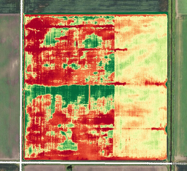
Plant health algorithms such as NDVI and VARI (more on this below) compare the proportions of light captured across different bands (red, green, blue and sometimes near-infrared) to compute numerical values for each pixel or area of a given drone map. Maps with plant health algorithms are then assigned colors based on those numerical values, which makes it easy to identify the variance between healthy and unhealthy areas.
What Kind of Camera Do I Need to Evaluate Plant Health with DroneDeploy?
There are several types of cameras that can help you evaluate plant health, but ultimately you should choose one to meet your individual requirements. We recommend starting simple to see what value can be extracted from your existing drone hardware before investing in more expensive systems. You can always upgrade and invest more in your drone hardware from there.
Let’s take a look at the most common types of cameras used for drone mapping in agriculture.
RGB Cameras
RGB — or standard — cameras capture Red, Green, and Blue light. This is the camera type that comes stock with most drone models like the Phantom 4 Pro or Mavic Pro.
Benefits of RGB Sensors
We recommend that growers and service providers who are starting to map with drones stick with RGB sensors for a couple of reasons. For one, RGB imagery is more accessible and can be captured with the average camera — making it an affordable option that doesn’t require the need to invest in additional sensor technology. Additionally, RGB cameras capture images similar to what is seen with the human eye, meaning it is more familiar and easier to interpret — even without the use of plant health algorithms. RGB cameras are also multipurpose, meaning they are able to take pictures for making detailed orthomosaic drone maps; they are also capable of capturing high quality videos.
Near Infrared (NIR) Cameras
There are two main types of NIR cameras: Modified RGB cameras for Near Infrared and Multispectral Cameras. These tend to be more expensive in general, but there are a wide variety of options available on the market to choose from. Let’s take a closer look.
RGB Cameras Modified for Near Infrared
Modified cameras are fitted with a filter to capture some combination of Near Infrared, Red, Green and Blue light depending on the model.
Multispectral Cameras
Multispectral cameras capture Red, Green and Near Infrared light. (Note: at the time of this posting DroneDeploy does not support image processing with multispectral cameras, but you can collect multispectral data with some of our App Market partners such as Slantrange and export to DroneDeploy for analysis)
RGB cameras modified with NIR filters and multispectral cameras deliver high performance and accurate (absolute) NDVI imagery, but they require substantially higher investment than standard RGB cameras. Quality NIR-capable cameras can cost anywhere from $1,200USD on the lower end, to $7,000USD on the high end. Additionally, while many aftermarket camera conversions for DJI cameras are available, image quality is inconsistent across manufacturers, meaning some may lead to poor map quality
What Type of Plant Health Algorithm Should I Use?
We recommend you use the algorithm that is intended for the type of imagery you collect. Start with the RGB no matter how serious you are about measuring crop variability with drones, you can always move up from there and increase your investment.
Let’s take a look at some of the most common plant health algorithms being used in the industry today.
What is VARI?
The Visible Atmospherically Resistant Index (VARI) was designed and tested to work with RGB sensors. VARI is a measure of “how green” an image is. VARI is not intended as a substitute for an NIR camera, but it is meaningful when working with non-NDVI imagery. RGB images with the VARI algorithm applied make it possible to detect areas of crop stress in a field.
Why Use RGB Sensors and the VARI Algorithm?
Many growers are only seeking to understand the relative plant health of their fields. RGB imagery with the VARI algorithm provides useful information related to variance at a single point in time, and can be a valuable tool to help farmers identify stress and generate variable rate prescriptions. Many DroneDeploy customers report that RGB imagery is more than enough to identify variability and gain actionable insights about their crops.

What is NDVI?
The Normalized Difference Vegetation Index (NDVI) is a commonly used remote sensing technique that identifies vegetation and measures a plant’s overall health. NDVI has been the standard for understanding plant health in the agriculture industry for many years. In the past, Near Infrared imagery has typically been captured by satellites or manned aircraft, but now drones are changing the game. Previously, it may have taken weeks or more to receive NDVI imagery from satellites. Today, growers and agronomists can purchase drones and NIR-capable cameras to collect NDVI imagery on demand, making it both more affordable and accessible than previous methods.
NDVI relies on the comparison of near infrared light to measure healthy plant life across a wide range of conditions.
Why Use Modified RGB and Multispectral Cameras and the NDVI Algorithm?
Growers, agronomists, and drone service providers (DSPs) who are seeking to understand comparative plant health data over time may wish to use NDVI imagery captured using RGB cameras that are modified with an NIR filter, or use Multispectral cameras. These cameras are specifically designed for agricultural needs. This means that any NDVI images produced are better suited to analyze and detect the smallest amount of crop stress by reading the near-infrared light and picking up on any reflection from plants. Sometimes it can be possible to identify crop issues a few days earlier than with standard RGB sensors.
What is False-NDVI?
In your research, you may have come across the term “false-NDVI.” This refers to the NDVI algorithm applied to RGB imagery. While some growers may find false-NDVI useful, we don’t recommend applying NDVI to RGB imagery because the algorithm was not designed for that purpose. As a result, this results in the reporting of inaccurate data. As mentioned above, the VARI formula is a much more useful way to calculate plant health using RGB imagery.
Remember that no matter which algorithm you choose to measure plant health, you should follow up with inspection. Measuring plant health allows you to see variability, but it won’t tell you why that variability exists. You should always get out in the field to ground-truth any crop variance you discover. This, combined with historical knowledge of the field, will allow you to determine the best course of action moving forward.

