NDVI Mapping with Drones
Comparing Sensors and Systems for NDVI Mapping
NDVI Mapping
Not sure where to start with NDVI mapping? What is NDVI Mapping? Here we cover the basics, along with several systems and options available today. We compare different sensors and different systems at an easy to understand level.
NDVI
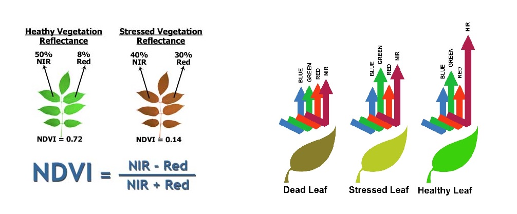
There are a few different indexes but Normalized Difference Vegetation Index (NDVI) is the most commonly used. It is an algorithm calculated from the reflectances of the Red (R) and Near Infrared (NIR) spectral bands. Basically, with the use of NDVI or similar systems (NDRE, GNDVI, VARI) we can produce a crop health map that indicates stressed areas that we cannot see with the naked eye. Some Sensors give you plant counts, yield potential and also weed populations.

RGB Cameras with Dronedeploy
This system uses the standard RGB camera and DJI drones like the Phantom 4. With Dronedeploy you plan a mission over the field that you want to collect data from. The program flies the drone and once the mission is complete the images are uploaded to the Dronedeploy cloud. Once the upload is complete the images are processed and several maps are available including NDVI crop health, 2D and 3D maps. It is important to have the settings VARI and RGB selected in Dronedeploy. We have used this system with good results and recommend it for entry level crop health monitoring.
The use of this system comes with a level of controversy, there are schools of thought of the accuracy and validity of this method. Through our own use of this system, we find it a good economical way to learn the basic principles of NDVI data collection.
Satellite Imagery
NDVI mapping can be obtained through subscription to satellite services. This is also a good way to obtain NDVI information but resolution is lower than when using drones. This system give you access to biomass maps from satellite imagery. With the use of drones the data produced is also in real time. Each option has an advantage in its application.
Multispectral Sensors
These sensors provide more accurate data than the systems mentioned previously. Multispectral sensors consist of several bands including Blue, Green, Red, Near Infrared(NIR) and Rededge.
Let’s have a quick look at a few popular multispectral sensors on the market today.
Parrot Sequoia
The Parrot Sequoia multispectral camera has a 16mp RGB camera and also green, red, NIR and Rededge bands.
The complete kit weighs only 107gms and is why the Parrot Sequoia is a widely used sensor, and also due to it’s small size and ease of integration on a wide range of drones.
Data processing for this sensor is usually done with Pix4D or Solvi mapping after the flight.
Resolution is 13cm/pixel GSD at 120 metres
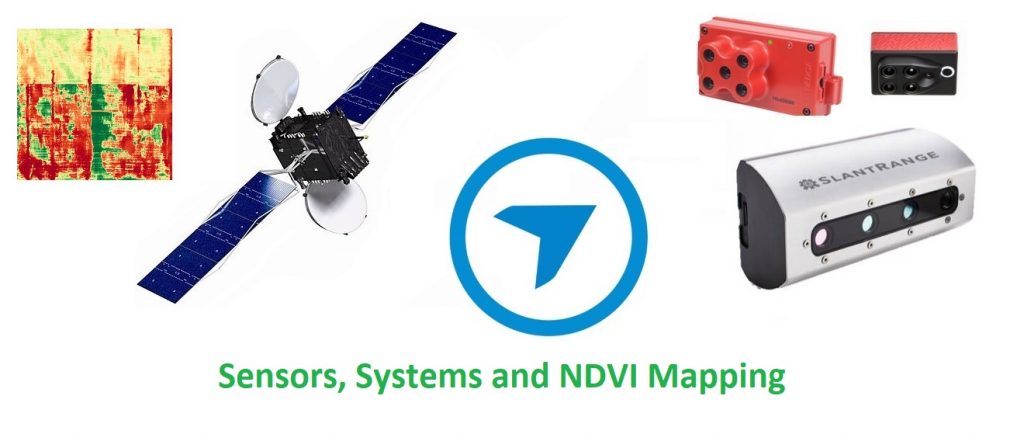
Slantrange 3P
The Slantrange 3P multispectral camera has green, red, NIR and Rededge bands. Coupled with Slantview software the drone fitted with the Slantrange 3P can be flown at 20% overlap. This reduces the number of passes and increasing the area covered per flight by up to 4 times. Processing can be done in the field and takes approximately 20 minutes without the need for internet. If you want to use Pix4D to process maps, your flights will need to be flown at 80% overlap
Weighs 350gms including sunshine sensor, the use of a sunshine sensor or AIS (Ambient Illumination Sensor) was introduced to Multispectral sensors by SLANTRANGE, click here to read more about the development of the AIS here.
Resolution is 4.8cm/pixel GSD at 120 metres.
The 3P sensor has been replaced with the Slantrange 4P multispectral camera with improved resolution and data management.
Micasense RedEdge
This RedEdge multispectral sensor from Micasense has blue, green, red, NIR and Rededge bands for data collection and can be processed with Pix4DAg or Solvi mapping.
Weighs 175gms including sunshine sensor.
Resolution is 8cm/pixel GSD at 120 metres.
Agrowing Cameras
Agrowing have developed multispectral lens systems for Sony cameras for high quality data and excellent resolution.
Integration Kits
We produce kits for mounting the Multispectral cameras onto drones. We have developed kits using 3D printing technology,
These kits suit the Mavic Pro, Mavic 2 Pro and Phantom 4 drones. We can customise a sensor mount to suit your application.
Hyperspectral Sensors
While Multispectral sensors collect data over up to 10 bands, Hyperspectral sensors collect data over hundreds of bands. Hyperspectral imagers not commonly used in Agriculture at the moment but when the need for more specific information is required then we will see more of these sensors.

