Solvi NDVI Data Processing
Real insights and actionable data in few simple steps, Solvi NDVI Data processing and analysis of drone imagery in a matter of few simple clicks. Now you can focus on what’s really important.
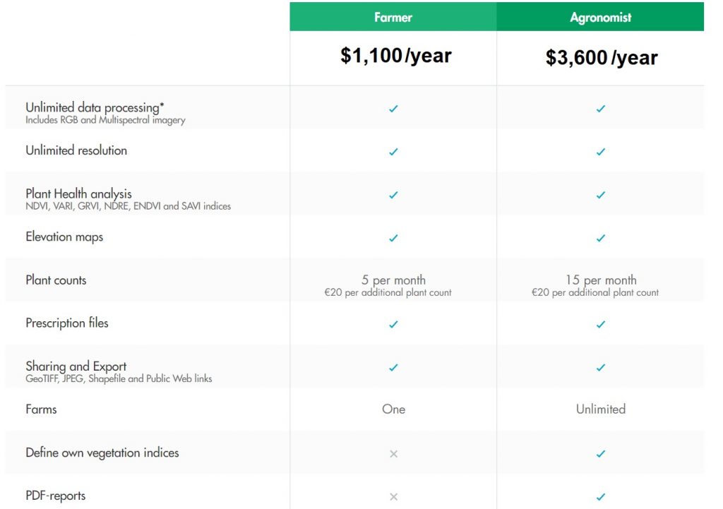
Whether you’re a farmer or agronomist, Solvi has a data processing solution for you. In the farmer package you are able to have one farm and all of your paddocks shown. In the agronomist package you can have multiple farms.

Plant Health analytics
- Predefined or custom Vegetation indices like NDVI, NDRE or VARI help locate field variations caused by plant stress, water damages, pests, deseases etc.
- Elevation maps correlate differences in elevation profile to crop health
- Over the time comparison allows tracking changes in crop development throughout the season
Accurate Plant Counts
- Total number of plants for the whole field or custom defined areas helps evaluate sowing quality and crop emergence
- Number of missing plants helps detect areas of potential crop loss for replanting
- Works with a variety of crops including cauliflower, broccoli, corn, salads, potatoes, pumpkin, sunflower and more

High Resolution Prescription files
Turn plant health maps into management zones and create prescription files with up to 1m resolution. Prescriptions are compatible with most spreaders available on the market, including John Deere and Trimble.
- Up to 1m resolution
- Export to Shapefiles
- Compatible with most spreaders
Fully automated unlimited processing
Fly and collect imagery over your fields as often as you need. Simply upload data to Solvi and we’ll process, organise and visualise it. We don’t limit amount of data you process and always give you highest possible resolution, whether you need to get high level overview or detect weeds or individual plants.

Solvi works well with your favourite DJI or Yuneec drone. If you have one of the following – Parrot Sequoia or Micasense Rededge Multispectral Cameras you can also get detailed NDVI data.
| Choose your plan | Farmer Software, Agronomist Software |
|---|


